

After the eruption of the volcano, a new threat | If part of the mountain falls into the sea, there will be a tsunami
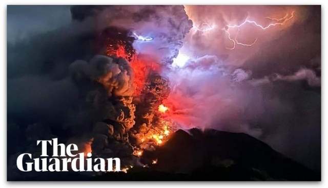
Mount Ruang, a stratovolcano located in the province of North Sulawesi (Indonesia), has caused a series of eruptions, due to which the authorities have raised the alert level to maximum.
The eruption began at 9:45 p.m. local time on Tuesday and repeated four times the next day, according to the Indonesian Volcanology Agency.
Noticing a significant increase in volcanic activity, the agency quickly raised the warning level from three to four, the highest on the scale.
Hendra Gunawan, head of Indonesia’s volcanology agency, stressed that the decision was based on visual and instrumental assessments that indicated increased volcanic unrest.
In response to the growing threat, authorities expanded the exclusion zone around the crater from 4 to 6 kilometers.
More than 800 people from two villages on Ruang Island were evacuated to safety on Tagulandang Island, located about 100 kilometers north of Manado, the provincial capital.
Everyone is on alert
Although there are no reports of casualties so far, officials are still on high alert as the Ruang volcano poses multiple hazards such as rockfall, hot clouds and a possible tsunami as part of the mountain falls into the sea. Gunavan urged Tagulandan residents to evacuate outside the extended 6-kilometer radius by Wednesday evening.
Muhammad Wafid, head of the geological agency, revealed that the initial eruption on Tuesday threw an ash plume 2 kilometers high, and subsequent eruptions reached a height of 2.5 kilometers. The volcanological agency has noted an increase in volcanic activity following two recent earthquakes nearby.
Indonesia, located in the Pacific Ring of Fire, witnesses frequent seismic and volcanic events due to the convergence of the tectonic plates, which run from Japan through Southeast Asia to the Pacific Basin.
As Mount Ruang continues to show increased activity, authorities remain on high alert, prioritizing the safety and evacuation of affected communities.
A terrible event in the 19th century
Ruang is the southernmost stratovolcano in the Sangihe Archipelago. It consists of an island with a width of 4 to 5 km. The peak contains a partial lava dome and reaches about 725 m above sea level. From its summit you can see Klabatov peak to the south, Siau peak to the north and Ternate to the east.
The first recorded eruption was in 1808, and the German anthropologist Adolf Majer (1840-1911) witnessed a major eruption in 1871. Ruang was uninhabited at the time, but the people of nearby Tagulandan had many plantations on its slopes.
The eruption destroyed them in minutes and caused a tsunami that destroyed most of their large village, located on Tagulandan, opposite Ruang. Most of the villagers drowned, and their bodies could later be seen on the beach.


